- Home
- Village and history
From Çeçeva
to Haremtepe.
Two hundred years of records, one hillside, three different names.
At a glance
A village in the Çayeli district of Rize.
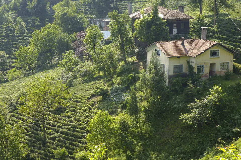
Haremtepe sits 24 kilometres from the city of Rize and 6 from the town of Çayeli, at an elevation of 508 metres. It is a dispersed Black Sea settlement: houses stand one by one across the slope, and every flat patch between them is given over to tea. It is still administratively a village, run by an elected headman (muhtar) and a council of elders.
The village's older name — still the one most people use — is Çeçeva. Maps, road signs and official correspondence say Haremtepe; visitors and social media stubbornly say Çeçeva. This site takes its name from that.
| Official name | Haremtepe |
|---|---|
| Former / local name | Çeçeva (recorded as Çaçeva, چاچوا) |
| Province / district | Rize / Çayeli |
| Region | Black Sea Region, Eastern Black Sea |
| Coordinates | 41°02′00″N, 40°44′02″E |
| Elevation | 508 m |
| Population | 549 (2025, TurkStat) — 273 men, 276 women |
| Postal code | 53260 |
| Dialling code | 0464 |
| Vehicle plate code | 53 |
| Livelihood | Tea farming; in recent years, day tourism |
Origin of the name
Çeçeva is a family name.
According to place-name research, Çeçeva comes from a Laz family name — it means, roughly, “belonging to the Çeçeva family”. The 1876 yearbook of the Trabzon Province records the settlement as “Çaçeva balad karyesi”, and in the Ottoman census register of 1835 the name reads Çeçeva.
The Lazeti region, where the village lies, fell within the Kingdom of Colchis in antiquity. After the Ottomans ended the Empire of Trebizond in 1461 they took this coastal strip gradually, gaining control of the whole region by 1547.
The name “Haremtepe” first appears in a Turkish source from 1913. An Ottoman-script village list of 1928 writes it as “Harem Tepe Beyaz Su”. In the 1960 general census the registrar's hesitation is plain to see: the village is entered as “Hramtepe (Çeçeva)”.
Timeline
The village in the records.
- 1835 — First censusÇeçeva is one of the 17 villages of the Mapavri (today Çayeli) sub-district. The register, which counted men only, lists 428 people; by 1846 the figure has fallen to 409.
- 1876 — Trabzon Province yearbook“Çaçeva balad karyesi”: 564 people in 131 households, the second most populous village in the sub-district. Fifty-seven oxen and 122 cows were assessed for tax — livestock and maize were the living then.
- 1913 — A new nameA Turkish source refers to the settlement as Haremtepe for the first time.
- 1928 — Ottoman-script village listRecorded as “Harem Tepe Beyaz Su”, a village of the Mapavri sub-district in Rize province.
- 1935 — General censusHaremtepe then lies within Çoruh province; the population is 1,311.
- 1945 — Çayeli becomes a districtThe Mapavri sub-district is turned into the Çayeli district; Haremtepe is attached to its central sub-district.
- 1965 — Approaching the peak1,554 people live in the village; 404 of them are literate.
- 1985 — The most crowded years1,711 people. What follows is the same story as everywhere else in Türkiye: migration to the cities.
- 2019 — DiscoveryThe tea garden Kenan Çiftçi shaped over decades reaches national media and social networks, and the village fills with visitors.
Population
Down to a third in forty years.
From 1,711 in 1985 to 549 in 2025. The village fills up again in summer: families living in the cities come back for the harvest, for the holidays, or simply to see the garden. The permanent winter population is far lower.
Village population by year. Sources: TurkStat and YerelNet.
| Year | Population | Change | |
|---|---|---|---|
| 1935 | 1,311 | — | |
| 1965 | 1,554 | +243 | |
| 1985 | 1,711 | +157 | |
| 1990 | 1,553 | −158 | |
| 2000 | 1,136 | −417 | |
| 2010 | 730 | −406 | |
| 2018 | 814 | +84 | |
| 2020 | 719 | −95 | |
| 2025 | 549 | −170 |
Geography and daily life
Steep slopes, scattered houses, tea everywhere.
The settlement pattern typical of Eastern Black Sea villages holds here too: the village does not gather around a single centre, the houses spread across the hillside. Each household has its own tea plot, its own water channel, its own path. The distances look short, but the gradient makes walking them tiring.
Tea became the region's single dominant crop after the 1940s. Before that there was maize, hazelnuts and livestock — the ox and cow count in the 1876 yearbook records exactly that. Today the village lives largely on fresh tea leaf and, in recent years, on day visitors.
The tea gardens